


156.01-Voting District 156, Area 1, County, Brevard County, Florida
About
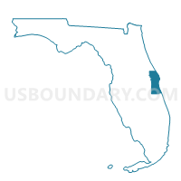
Outline

Summary
| Unique Area Identifier | 551135 |
| Name | 156.01-Voting District 156, Area 1, County |
| County | Brevard County |
| State | Florida |
| Area (square miles) | 5.11 |
| Land Area (square miles) | 1.83 |
| Water Area (square miles) | 3.28 |
| % of Land Area | 35.79 |
| % of Water Area | 64.21 |
| Latitude of the Internal Point | 28.50350030 |
| Longtitude of the Internal Point | -80.78120870 |
Maps


Graphs
Select a template below for downloading or customizing gragh for 156.01-Voting District 156, Area 1, County, Brevard County, Florida


Neighbors
Neighoring Voting District (by Name) Neighboring Voting District on the Map
- 118-Voting District 118, County, Brevard County, FL
- 126-Voting District 126, Port St John Area, County, Brevard County, FL
- 15-Voting District 15, North Merritt Island, County, Brevard County, FL
- 158-Voting District 158, Port St John Area, County, Brevard County, FL
- 182-Voting District 182, Kennedy Space Center, County, Brevard County, FL
- 193.09-Voting District 193, Area 9, County, Brevard County, FL
- 72-Voting District 72, Titusville, Brevard County, FL
- 74.01-Voting District 74, Area 1, County, Brevard County, FL
Top 10 Neighboring County Subdivision (by Population) Neighboring County Subdivision on the Map
- Cocoa-Rockledge CCD, Brevard County, FL (117,219)
- Titusville CCD, Brevard County, FL (66,206)
- Merritt Island CCD, Brevard County, FL (42,611)
- Space Center CCD, Brevard County, FL (65)
Top 10 Neighboring Place (by Population) Neighboring Place on the Map
Top 10 Neighboring Unified School District (by Population) Neighboring Unified School District on the Map
Top 10 Neighboring State Legislative District Lower Chamber (by Population) Neighboring State Legislative District Lower Chamber on the Map
Top 10 Neighboring State Legislative District Upper Chamber (by Population) Neighboring State Legislative District Upper Chamber on the Map
Top 10 Neighboring 111th Congressional District (by Population) Neighboring 111th Congressional District on the Map
Top 10 Neighboring Census Tract (by Population) Neighboring Census Tract on the Map
- Census Tract 712, Brevard County, FL (12,889)
- Census Tract 699.01, Brevard County, FL (7,926)
- Census Tract 621.04, Brevard County, FL (6,989)
- Census Tract 612.01, Brevard County, FL (6,650)
- Census Tract 621.08, Brevard County, FL (6,626)
- Census Tract 711, Brevard County, FL (3,880)
- Census Tract 612.02, Brevard County, FL (3,870)
- Census Tract 621.06, Brevard County, FL (3,271)